Mayo County Council has recently developed a series of Fit Stick Walking Trails. These accessible trails have been developed for individuals with mobility challenges and cater for people of all ages and abilities.
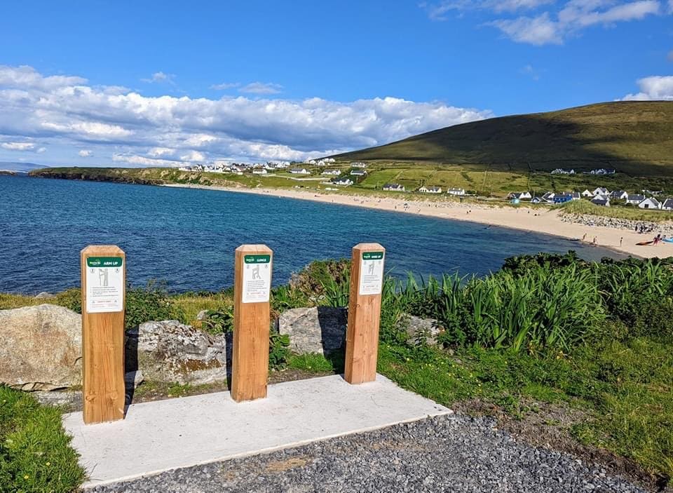
The trailhead for the Doogort Fit Sticks Trail is situated opposite the picturesque Silver Strand Blue Flag Beach. The beach is set amidst a charming holiday home area and is a popular destination for both locals and tourists alike, who come to enjoy the crystal-clear waters and indulge in various recreational activities. The trail offers magnificent views of Sliabh Mor mountain and the surrounding landscape and is a great way to immerse yourself in the beauty of Achill Island.
Region: Achill Island
Start / Finish / Trailhead: Doogort Strand Carpark
GPS Location: 54.0106, -10.60228
Map Reference: OS Discovery Series – sheet 30
Direction: Black Post with green travel arrow
Distance: 3 km
Terrain: Mix of paved roads and laneways
Grade: Easy
Estimated Time: 1 -1.5 hours
Minimum Gear: Sturdy walking shoes / boots, waterproofs, mobile phone, snacks & fluids
Services: Available throughout Achill Island.
The Lacken Fit Sticks Trails offer a scenic route by Lackan bay with several archaeological sites along the way. Nature lovers will love these walks which take you by bog, heath, farmland and sand dunes.
Region: Lacken, Killala
Start / Finish / Trailhead: Lacken Church Carpark
GPS Location: 54.2741, -9.2582
Map Reference: OS Discovery Series – sheet 24
Direction: Lacken Trail – Black Post with green travel arrow
Rathlacken Trail – Black Post with blue travel arrow
Distance: Lacken Trail – 4 km
Rathlacken Trail – 8 km
Terrain: Mix of paved and bog road, laneway and grassy tracks
Grade: Lacken Trail – Easy / Rathlacken Trail – Moderate
Estimated Time: Lacken Trail – 1 -1.5 hours / Rathlacken Trail – 2- 2.5 hours
Minimum Gear: Sturdy walking shoes / boots, waterproofs, mobile phone, snacks & fluids
Services: Killala and Ballycastle
A walk to the Deserted Village at the foot of Slievemore Mountain is a journey back in time. The remains of 80 plus small stone cottages tells us that this was once a well populated area. However, the Great Irish Famine of the 1840s caused the abandonment of the village and now only the ruins of the cottages remain.
The Dooagh trail and the Pollagh Trail are two shorter Fit Sticks walks which also start at Doogort Strand Carpark.
Region: Achill Island
Start / Finish / Trailhead: Doogort Strand Carpark
GPS Location: 53.9741, -10.1260
Map Reference: OS Discovery Series – sheet 30
Direction: Deserted Village Trail – Black Post with Blue travel arrow
Dooagh trail – Black Post with Purple travel arrow
Pollagh Trail – Black Post with Green travel arrow
Distance: Deserted Village Trail – 10 km
Dooagh trail – 5 km
Pollagh Trail – 3.5 km
Terrain: Mix of paved roads, bog roads and laneways
Grade: Moderate
Estimated Time: Deserted Village Trail: 2.5 – 3 hours
Dooagh trail: 1.5 – 2 hours
Pollagh Trail: 1 – 1.5 hours
Minimum Gear: Sturdy walking shoes / boots, waterproofs, mobile phone, snacks & fluids
Services: Available throughout Achill Island
Mayo County Council has recently developed a series of Fit Stick Walking Trails. These accessible trails have been developed for individuals with mobility challenges and cater for people of all ages and abilities. The Trails are suitable for Nordic walking and offer rest areas, exercise stations and distance markers.
The initiative was developed in collaboration with local community groups, HSE, Mayo County Council and Mayo Sports Partnership. The Fit Stick Trails promote physical activity, inclusivity, and overall wellbeing in the community.
Funding was made available under the Sláintecare Healthy Communities Programme.